The Faroe Islands, an archipelago of 18 volcanic islands nestled amidst the North Atlantic Ocean between Iceland and Norway, emerges from its winter slumber in springtime, unveiling a breathtaking panorama of landscapes that are ripe for photography.
This season brings a vibrant palette of colors, from the verdant green meadows to the vibrant wildflowers that carpet the rolling hills. The dramatic cliffs adorned with lush vegetation, the serene waterfalls cascading down the rugged terrain, and the captivating interplay of light and shadow on the azure waters create a symphony of natural beauty that is sure to inspire photographers of all levels.
The absence of crowds during this season further enhances the photographic experience, allowing you to capture the islands' natural beauty in tranquility and more relaxed locals.
Here are the 20 must-visit photo spots for the Faroe Islands (this map provides an overview. You can read the text below for all details about the photo spots, such as where to park and when to shoot).
Here is a sneak preview video with the best photos of the Faroe Islands. To get you in the mood to discover the photo spots.
Reaching the Faroe Islands: A Comprehensive Guide
Whether you're embarking from the UK, mainland Europe, or overseas, reaching these remote islands is an adventure in itself. Here's a comprehensive guide on how to navigate your journey to this enchanting archipelago.
From the UK:
For those departing from the UK, the most convenient option is to fly directly from Edinburgh. Atlantic Airways, the national carrier of the Faroe Islands, offers regular direct flights from Edinburgh to Vágar Airport (FAE), the main international gateway to the Faroe Islands. Flight times typically range from 2 to 3 hours, making it a relatively quick and hassle-free journey.
From Mainland Europe:
If you're traveling from mainland Europe, several options are available. Atlantic Airways offers direct flights from Copenhagen, Denmark, and Reykjavik, Iceland, to Vágar Airport. Additionally, you can opt for connecting flights via major European hubs like Amsterdam, Frankfurt, or Paris. Airlines like SAS, Lufthansa, and Air France offer regular connecting flights to the Faroe Islands. Flight times vary depending on the chosen route, but typically range from 4 to 8 hours. Some flights might be seasonal and only fly in summer or in spring.
From Overseas:
For those traveling from overseas, reaching the Faroe Islands may require multiple connections. However, it's still very doable with careful planning. You can consider connecting flights via Iceland or mainland Europe. Flight times from overseas can be longer, ranging from 8 to 14 hours, but the journey is worth the reward of experiencing the Faroe Islands' unique beauty.
Tips for a Smooth Journey:
- Book your flights in advance, especially during peak seasons, to secure the best rates and availability.
- Consider flying during the off-season (October to March) to enjoy lower fares and fewer crowds.
- Check visa requirements if you're traveling from outside the Schengen area.
- Pack appropriately for the Faroe Islands' cool and often unpredictable weather.
How long do you need to discover the Faroes?
To truly capture the essence of these islands, you'll need to spend enough time to explore them at a leisurely pace.
A Minimum of One Week
A minimum of one week is recommended to get a good feel for the Faroe Islands and explore the main photo locations. This will allow you to cover the southern islands, including Tórshavn, the capital, and the picturesque village of Gásadalur. You'll also have time to venture further north and south.
Two Weeks for an In-Depth Experience
If you can spare two weeks, you'll have the luxury of exploring the Faroe Islands in depth. This will allow you to delve into the more remote islands and discover hidden gems off the beaten path. You'll also have ample time to photograph the islands in different conditions, from sunrise to sunset, and capture the ever-changing moods of the North Atlantic weather.
A Long Weekend for a Taste of the Faroes
If you're limited to a long weekend, don't despair. You can still get a taste of the Faroe Islands' beauty by focusing on a few key locations. Choose two or three photo spots I listed in this blog that particularly appeal to you, and immerse yourself in their unique charm.
what's the Weather like?
Faroe's unpredictable weather adds a challenge to any photo adventure. But there's a way to get a little more control...
Wish you could make the weather cooperate for your perfect shot? Photrus comes close.
Red sunsets over Skye? Pink Tuscan sunrises? Iceland's dancing aurora? Photrus delivers.
Set alerts for breathtaking sunsets, shimmering lochs, wild waves...whatever your photographic heart desires.
Pick your location, define your ideal conditions, and get notified 1-2 days before the magic happens.
Take charge of your photography – visit www.photrus.com
It's not free, but for photographers who are serious about chasing the right light, it's a valuable tool. As a Photrus partner and a user myself, I highly recommend checking it out.
Where to stay in the Faroes?
The best accommodation option for photographers depends on your preferences and itinerary.
Tórshavn: If you enjoy having a variety of amenities at your doorstep, Tórshavn is a great choice. The capital city offers a lively atmosphere, plenty of restaurants, supermarkets, and cafes, and easy access to southern photo locations.
Streymoy or Eysturoy: For a more strategic base, consider staying on the islands of Streymoy or Eysturoy. These centrally located islands are well-connected by bridges and tunnels, making it easy to explore both northern and southern photo spots. For an authentic Faroese experience, consider renting a traditional cottage in one of the middle islands. This will give you more flexibility to explore early in the morning or late at night, and you'll get a true taste of Faroese life.
Split Stay: If you have enough time, consider splitting your stay between the island of Vagar, where the airport is located, and the northern town of Klaksvik. This will allow you to explore both ends of the Faroe Islands and capture diverse landscapes.
No matter how long you choose to spend in the Faroe Islands, you'll be rewarded with an unforgettable photography experience. The islands' rugged beauty and unique atmosphere will leave you captivated, and you'll return home with a collection of images that will forever remind you of your Faroese adventure.
20 Must-Visit Photo Spots in the Faroe Islands
1. elduvik


Elduvik: A Picturesque Village and the gorge with steep stairs in the Faroe Islands.
Its picturesque harbour, rugged coastline, and charming traditional houses, Elduvik exudes a captivating charm that has captivated already many photographers.
How to get there:
Elduvik is situated on the northeastern coast of Eysturoy, the second-largest island in the Faroe Islands. From Tórshavn, the capital, follow the scenic Route 10 northwards, enjoying the breathtaking views along the way. The journey takes approximately 45 minutes by car.
Best time:
Any time of the day.
Parking:
Parking is readily available near the harbour, providing easy access to the main photographic areas. The village is small and easily walkable, allowing you to explore its charming streets and alleyways at your own pace.
Where to shoot:
There are two main spots: The harbour with - if you are lucky - some traditional boats and great views to the colourful houses. And the gorge, the natural harbour with steep stairs, forming a
perfect leading line for your photos.
To reach Gorge Elduvík from Elduvik Village, follow a straightforward 0.6-kilometer footpath that takes approximately 10 minutes to traverse.
Commence your journey from Elduvik Church, heading eastwards towards the picturesque harbor. At the first junction, make a right turn onto a well-maintained dirt road that winds through the
countryside. Continue along this path for approximately 500 meters until you arrive at the captivating Gorge Elduvík.
==>> SEE MORE PHOTOS <<==
2. fossa waterfall
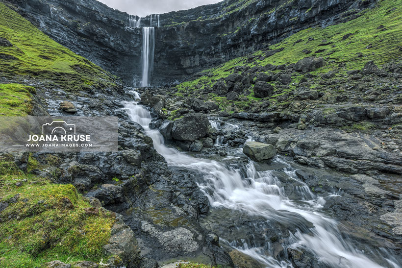

Nestled amidst the rugged landscapes of Streymoy, the largest island in the Faroe Islands, Fossa Waterfall stands as a testament to nature's artistry. The waterfall's multiple tiers provide a variety of angles and perspectives, allowing photographers to capture the dynamic flow of water from different vantage points.
How to get there:
Follow Route 50 and 10 northwards. After approximately 45 minutes, take the exit signposted towards Haldarsvík. The waterfall is located just next to the main road.
Best time:
An overcast day will be the best option.
Parking:
There is a small lay-by along the main road, only a few meters away from the falls. It can get busy during peak times.
Where to shoot:
The main spot is probably from the road with the waterfall as a majestic backdrop. There is also a (muddy) path leading up to the falls.
==>> SEE MORE PHOTOS <<==
3. Bøur


The village's history dates back to Viking times, and evidence suggests that it was once a thriving settlement. Today, Bøur retains its traditional charm with its cluster of grass-roofed houses, known as turf houses. These distinctive dwellings, constructed from stone and earth, offer a glimpse into the Faroe Islands' rich heritage and make a great photo opportunity with the islet Tindhólmur and the sea stack Drangarnir as a backdrop.
Reaching Bøur from Tórshavn
take the main road towards Vágar Airport. Just before reaching the airport, turn left onto a narrow road that leads to Sørvágur, the largest village on Vágar. Continue through Sørvágur and follow the signs for Bøur. It is a drive of 50 minutes.
Best time:
The morning hours are best to get the light on the houses and islets.
Parking:
There is a car park just before the village itself.
Where to shoot:
From the car park you can walk into the village itself with its authentic houses and a lovely church (5 mins).
If you walk into the other direction along the main road, you will find a cluster of traditional turf-roofed houses, known as 'græshús' (10 mins).
==>> SEE MORE PHOTOS <<==
4. Funningur


Steeped in history, Funningur is said to be the site of the first Viking settlement in the Faroe Islands, a testament to its rich cultural heritage.
The village's quaint beauty unfolds as you explore its winding streets and admire its traditional Faroese houses. However, the true photographic gem of Funningur lies in its turfed church, a harmonious blend of architecture and nature.
How to get there:
Funningur is easily accessible from Tórshavn. Embark on a scenic drive through the Eysturoy Tunnel, which connects Streymoy and Eysturoy Islands. The drive takes approximately 45 minutes from Tórshavn.
Best time:
For optimal photography conditions, plan your visit to Funningur during the evening hours. As the sun begins its descent, the village and the vis-a-vis cliffs are bathed in a warm, golden light, creating a picturesque backdrop for your photographs. Avoid photographing in the morning as the backlight will make it challenging to capture well-lit images.
Parking:
From the parking area in the village (near river), a leisurely stroll along the riverbank leads you to the turf-roofed church. The walk takes approximately 5 minutes.
What to shoot:
The rustic charm of the turfed church and picturesque setting against the backdrop of the fjord make it a photographer's delight.
For panoramic views of the village, the cliffs, and the majestic mountains, take a short drive uphill along the winding road. The vista from the top is truly awe-inspiring.
==>> SEE MORE PHOTOS <<==
5. Múlafossur Waterfall
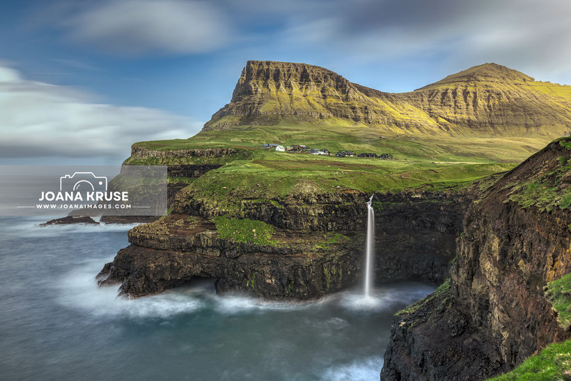

On the western coast of Vágar Island in the Faroe Islands, where rugged cliffs meet the vast expanse of the Atlantic Ocean, lies the captivating Múlafossur Waterfall. Plunging over 30 meters into the churning sea below, Múlafossur mesmerizes visitors with its raw power and breathtaking beauty.
How to get there:
From Tórshavn, follow the main road past the airport and continue until you reach the Gásadalstunnilin tunnel. Once you emerge from the tunnel, follow the signs for Gásadalur, a small village nestled at the foot of the cliffs where Múlafossur Waterfall resides. The drive takes approximately 30 minutes.
Best time:
For the most captivating photographs, visit Múlafossur Waterfall during the early morning hours or the evening hours. Sunrise presents a tranquil atmosphere with fewer crowds and vibrant hues in the sky. In the evening hours, the waterfall and cliffs are illuminated by the soft, golden light of the setting sun, creating a magical spectacle.
Parking:
Upon arriving in Gásadalur, you'll find ample parking near the village center.
Where to shoot:
From the parking area, a short and easy walk along a well-maintained path leads you to the waterfall viewing platform. The walk takes approximately 15 minutes.
==>> SEE MORE PHOTOS <<==
6. Gjógv


Perched on the northeastern tip of Eysturoy Island in the Faroe Islands, the secluded village of Gjógv offers a captivating blend of natural wonders and cultural heritage. Its name, meaning 'gorge' in Faroese, aptly describes the village's defining feature – a 200-meter-long sea-filled gorge that cuts deep into the coastline, creating a dramatic natural harbour.
How to get there:
From Tórshavn, follow the main road towards the Eysturoy Tunnel, which connects Streymoy Island to Eysturoy Island. Once you emerge from the tunnel, follow the signs for Gjógv, a scenic drive along the eastern coast of Eysturoy. The drive takes approximately one hour.
Best time:
For the most captivating photographs of the gorge, consider visiting on an overcast day. The diffused light will help to soften the harsh contrasts between the cliffs and the water, creating a more balanced and ethereal composition. Sunset, on the other hand, offers the ideal conditions for capturing the clifftop view, as the warm hues of the setting sun illuminate the village and the surrounding hills.
Parking:
Upon arriving in Gjógv, ample parking is available in the village. From the parking area, a stroll along a paved path leads you to the viewing platform overlooking the gorge.
Where to shoot:
Walk from the parking area down to the gorge and natural harbour (10 mins). Just above the gorge there is the walking path to the clifftop panorama view (from parking 25 mins).
The village itself along the river is also well worth a photo or two.
==>> SEE MORE PHOTOS <<==
7. Mikladalur


Nestled on the northern tip of Kalsoy Island in the Faroe Islands, the charming village of Mikladalur is famed for its connection to the mythical seal woman, Kópakonan, and its breathtaking natural beauty. The village name, meaning 'large valley' in Faroese, aptly describes its geographical setting – a spacious valley surrounded by towering cliffs and rugged coastline.
How to get there:
To reach Mikladalur, follow the signs for Klaksvík, the second-largest town in the Faroe Islands. From Klaksvík, take the ferry to Kalsoy Island. Please note that ferry reservations are not possible, and it is advisable to arrive early, especially during peak season, as the ferry is quite small and can fill up quickly. The ferry ride takes approximately 20 minutes.
Best time:
For the most captivating photographs of the Kópakonan statue, consider visiting in the evening hours. However, due to the ferry schedule, it may be challenging to capture the perfect sunset shot. Therefore, consider taking the very first ferry in the morning to make the most of your time in Mikladalur.
Parking:
From the parking area in the heart of the village, a steep downhill walk along a well-maintained path leads you to the Kópakonan statue. The walk takes approximately 10 minutes - return a bit longer due the the steepness...
Where to shoot:
Play with your long lens to show the Kópakonan close to the vis-a-vis cliffs.
There are also some turf houses in the village.
==>> SEE MORE PHOTOS <<==
8. Kallur Lighthouse


Standing sentinel on the northernmost tip of Kalsoy Island in the Faroe Islands, the Kallur Lighthouse has long guided mariners through the treacherous waters of the North Atlantic. Built in 1927, the lighthouse has become an iconic landmark, its whitewashed tower contrasting dramatically against the rugged cliffs and vast expanse of the ocean.
How to get there:
Drive to Klaksvík, the largest town on Bordoy Island. From Klaksvík, take the Smyril Line ferry to Kalsoy Island. Ferry schedules are subject to change and may be affected by weather conditions. It is advisable to arrive early for the ferry, especially during peak season, as the ferry can accommodate only a limited number of vehicles and passengers.
Best time:
The best time to photograph Kallur Lighthouse is early in the morning. Midday photography can be challenging due to backlighting. It is recommended to take the first ferry from Klaksvík to Kalsoy to make the most of the daylight hours and to avoid crowds.
Parking:
Upon arrival in Kalsoy, drive to the village of Trøllanes, where the hike to Kallur Lighthouse begins. Ample parking is available near the trailhead. The hike is approximately 3.9 kilometers long and takes about 2 hours to complete. The trail is moderately challenging, with a steep uphill section.
Where to shoot:
A narrow path is leading to the vantage point for the lighthouse. Due to the exposed nature of the path, it is not recommended to walk to the vantage point during high winds or for individuals with a fear of heights.
Don't forget to visit the nearby James Bond tombstone (just 5 mins uphill), a fictional grave marker erected for the agent in the 2021 film "No Time to Die."
==>> SEE MORE PHOTOS <<==
9 . Molin and the waterfall


Tucked away on the western coast of Streymoy Island in the Faroe Islands lies the charming village of Molin, renowned for its serene natural beauty and captivating waterfall. While less frequented than its more famous counterpart, Múlafossur, Molin's waterfall offers a secluded and equally stunning spectacle, earning it the title of 'Múlafossur's little brother'. Its name, meaning "mill" in Faroese, hints at the area's former use as a site for a watermill, long since vanished. Today, Mølin stands as a hidden gem, known to only a few locals and intrepid explorers.
How to get there:
Follow the main road towards Eiði, a picturesque village on the northern coast of Streymoy Island. Once in Eiði, turn right onto Malarvegur, a narrow road that leads to the beach. Continue along Malarvegur until you reach a sports field at the end of the road. Ample parking is available near the sports field.
Best time:
The best time to photograph Mølin is during the afternoon or evening when the sun illuminates the waterfall and cliffs, casting a warm glow upon the scene.
Parking:
From the parking area, a short hike leads you to Mølin Beach. The walk takes approximately 15 minutes and involves some climbing over rocks. Wear sturdy shoes and be cautious of the uneven terrain.
What to shoot:
The waterfall, framed by the rugged cliffs and the vast expanse of the ocean, creates a mesmerizing composition. Additionally, the tidal pools that form at the base of the waterfall provide a unique foreground element for capturing the power and beauty of the cascading waters.
==>> SEE MORE PHOTOS <<==
10. The nix


The Nix - a Mythical Sculpture in the Faroe Islands.
Emerging from the depths of Sørvágsvatn Lake on the Faroe Islands, the captivating sculpture of the Nix, a mythical water horse, stands as a testament to the region's rich folklore and artistic ingenuity. Unveiled in 2017, the sculpture, created by local artist Pól Skarðenni, has garnered international attention for its unique blend of mythology and contemporary art.
How to get there:
Follow the main road towards Vágar Airport, then turn left onto a narrow road (with a lot of pot holes) just next to the lake.
Best time:
Consider capturing the sculpture during an overcast day when the water's surface is still and reflective. Alternatively, venture to the lake at night when the sculpture is illuminated.
Parking:
Parking is available near the lake, and a short, easy walk leads you to the sculpture's viewing point. The walk takes approximately 5 minutes.
What to shoot:
Long exposure photography techniques, utilizing a tripod and ND filter, are recommended to capture the smooth texture of the water.
==>> SEE MORE PHOTOS <<==
11. Norðradalur


The name of the secluded village of Norðradalur means "Northern Valley" in Faroese, aptly describes the village's idyllic setting within a picturesque valley. A particularly photogenic spot in Norðradalur is the winding road that leads to the village, offering stunning views of the valley and the surrounding mountains. The road snakes its way through the landscape, creating a series of captivating S-curves that provide a dynamic composition for photographers.
How to get there:
The journey by car from Tórshavn is easy - it is only 12 mins and easy to find.
Best time:
The best time to photograph the Norðradalur landscape is during the early morning or late evening when the sun's rays are less harsh and create a more even and diffused light. Midday photography, on the other hand, can be challenging due to the strong backlighting.
Parking:
Along the road down to the coast, you'll find a lay-by with parking spaces. From the lay-by, you can walk along the grassy area overlooking the road to find the perfect spot for capturing the S-curves. The walk takes approximately 2 minutes and may be muddy or wet depending on the weather conditions.
What to shoot:
Position yourself on the hillside above the road to capture the road's curves, with the village and mountains as a picturesque backdrop.
==>> SEE MORE PHOTOS <<==
12. saksun


The name Saksun derived from the old Faroese word
"Saxun" meaning "marsh" and describes the village's idyllic setting amidst a tranquil lake and surrounding mountains. The village's iconic turf-roofed houses, nestled amidst lush greenery
and overlooking the tranquil lake, create a picturesque composition.
It is one of the most photographed spots in the Faroes - which makes it a bit difficult to get what you want because of overtourism and very annoyed (and sometimes even aggressive) locals.
How to get there:
Follow the main road towards Streymoy's northern coast. The drive from Tórshavn takes approximately 50 minutes.
Best time:
Consider visiting early in the morning - and I mean VERY early, with the first light - before the crowds arrive which starts at 8am. It gets very overcrowded with many coaches. Overcast days are also ideal for capturing the village's moody atmosphere, with the clouds adding a touch of drama to the landscape.
Parking:
Ample parking is available near the village, catering to both cars and coaches. From the parking area, a stroll along a paved path leads you into the heart of Saksun. The walk takes approximately 10 minutes.
Where to shoot:
For a unique perspective, capture the village from above, highlighting the contrast between the traditional houses and the vast expanse of the lake and mountains. Position the church nicely in
between the houses.
BUT: the locals hate photographers, so please be careful and mindful! Follow the designated paths and respect the privacy of the villagers. Be aware that photography can be disruptive to daily
life, so try to be as discreet as possible.
==>> SEE MORE PHOTOS <<==
13. Sandavágur


The name Sandavágur means Sand Bay" in Faroese and the sandy bay is exactly the foreground of the photo. The village's most iconic landmark is its distinctive red-roofed church, dating back to 1917. The church's vibrant red roof contrasts strikingly against the surrounding green hills.
How to get there:
From Tórshavn follow the main road towards Vágar Airport. IThe drive takes approximately 35 minutes.
Best time:
The best time to photograph the red-roofed church is during the afternoon or evening hours when the sun's rays illuminate the church and cast a warm glow upon the village.
Parking:
In the map link above I pinpoint the car park, the photo spot of the church is just next to the parking area.
What to shoot:
The red-roofed church, with its whitewashed walls and distinctive bell tower, has become a symbol of Sandavágur and a popular subject for photographers. For a captivating composition, consider framing the church against the backdrop of the village and the surrounding mountains. The nearby sandy bay can be used as a leading line, drawing the viewer's eye towards the church.
==>> SEE MORE PHOTOS <<==
14. Sornfelli


The summit of Sornfelli, a 749-meter mountain on Streymoy Island in the Faroe Islands, offers breathtaking panoramic views of the surrounding landscape. The viewpoint, accessible by a narrow and winding road, provides a stunning perspective of the Faroe Islands' rugged coastline, towering mountains, and scattered islets. The panoramic vista encompasses a vast expanse of the North Atlantic Ocean, with the rugged coastline of Eysturoy Island stretching into the distance. On a clear day, the peaks of distant mountains can be seen emerging from the horizon, adding a layer of depth and grandeur to the scenery.
How to get there:
From Tórshavn the drive will take approx. 20 mins. Follow Route 10 and turn left onto the very narrow street leading up the mountain.
Best time:
The best time to capture the panoramic vista from the Sornfelli Viewpoint is during the morning hours. clear day offers the best visibility, allowing you to see the peaks of the mountains
and the distant islands in sharp detail.
If you are planning to visit the Sornfelli viewpoint, be sure to check the weather forecast. Do not attempt to drive to the viewpoint on a rainy, windy, or foggy day, as the road is very
dangerous in these conditions.
Parking:
There is a large car park just next to the viewpoint.
What to shoot:
Go to the edge of the cliff to capture the best views. You may also stroll a bit down the road (see the photo above) to get nice shots of the mountains.
However, it is important to exercise caution and be aware of your surroundings. The path leading to the edge of the cliff is narrow and lacks railings, so it is essential to maintain a safe distance from the drop. Avoid visiting the viewpoint on windy days, as the strong gusts can make it difficult to stand safely near the edge.
==>> SEE MORE PHOTOS <<==
15. Trælanípa


On the western coast of Vágar Island in the Faroe Islands, the imposing Trælanípa cliffs stand sentinel above the serene Sørvágsvatn Lake, creating an optical illusion that has captivated visitors for centuries. The illusion of the 'floating lake' is caused by a combination of factors, including the positioning of the cliffs, the depth of the lake, and the angle from which it is viewed. When standing on the edge of the cliffs, the lake appears to be much closer to the cliff edge than it actually is, creating the illusion that it is about to spill over. The shallow waters near the cliffs, combined with the dark depths of the lake's interior, further enhance the illusion by making the lake appear to be suspended in mid-air.
How to get there:
To reach the Trælanípa cliffs from Tórshavn follow the main road towards Vágar Airport and follow the signs for the Trælanípa Visitor Centre. The drive takes approximately 40 minutes.
Best time:
The best time to photograph the optical illusion of Sørvágsvatn Lake from Trælanípa Cliffs is during the afternoon or evening hours when the sun illuminates the lake and cliffs, casting long shadows and enhancing the illusion's effect. However, be prepared for crowds, as this popular spot attracts visitors from around the world. If you prefer a more tranquil experience, consider visiting early in the morning before the visitor center opens. The gate will be unlocked, and you can still access the trail.
Parking:
Ample parking is available at the Trælanípa Visitor Centre. There is a small entrance fee to access the hiking trail. The hike from the visitor center to the viewpoint is approximately 50 minutes long. The trail is initially flat, but it becomes increasingly steep towards the end as you ascend the cliffs. If you arrive early in the morning before the visitor center opens, you can still enter the trail and pay upon your return. Sturdy footwear and a good level of fitness are recommended for this hike.
What to shoot:
For the most captivating shots, position yourself carefully on the cliff edge, ensuring the ground is stable and safe.
==>> SEE MORE PHOTOS <<==
16. Bosdalafossur waterfall


The Bøsdalafossur waterfall is tucked away on the western coast of Vágar Island, just a short hike from the Traelanipa Cliffs. It's not the biggest waterfall you'll ever see, but what it lacks in size, it makes up for in beauty. The cascading water plunges into the North Atlantic Ocean, creating a stunning seascape. But what really captured my attention was the presence of Geituskoradrangur, a majestic sea stack rising from the ocean just a short distance from the waterfall. This iconic rock formation, a remnant of ancient volcanic activity, adds an extra layer of grandeur to the scene.
How to get there:
This spot is best to be combined with the Trælanípa cliffs, see above.
To reach the Trælanípa cliffs from Tórshavn follow the main road towards Vágar Airport and follow the signs for the Trælanípa Visitor Centre. The drive takes approximately 40 minutes.
Best time:
The best time to photograph the Bøsdalafossur Waterfall is during the afternoon or early evening when the sun is positioned low in the sky, casting long shadows and accentuating the depth of the cliff face. However, if you prefer a more tranquil experience, consider visiting early in the morning before the crowds arrive.
Parking:
Ample parking is available at the Trælanípa Visitor Centre. There is a small entrance fee to access the hiking trail. The hike from the visitor center to the waterfall is approximately 60 minutes long (or 15 mins from the Trælanípa Cliffs).
What to shoot:
The additional walking time from the from Trælanípa Cliffs is only about 15 minutes, but it's worth noting that the path involves some climbing over rocks. Sturdy footwear and a good level of
fitness are essential.
Once you climbed over the rocks you can position yourself at the edge of the cliff to have a good overview of the seascape, the small waterfall and the sea stack as a focus point.
==>> SEE MORE PHOTOS <<==
17. Tjørnuvík


Tjornuvik, meaning "thorn village" in Faroese, is a small, traditional village with a population of just around 50 people. The black beach forms a sheltered bay, with view to the two towering sea stacks, Risin and Kellingin, standing guard at the entrance to the bay. These iconic rock formations, rising majestically from the ocean, are steeped in local legend. According to Faroese folklore, the sea stacks were once a giant and his wife who were turned to stone by a troll.
How to get there:
To reach Tjornuvik from Tórshavn by car, it will take 55 minutes.
Best time:
For photographers seeking to capture the sunrise, Tjornuvik offers a spectacular vantage point. The colorful sky reflected on the still waters of the bay creates a mesmerizing spectacle. However, for a more detailed view of the bay and its surroundings, afternoon or evening light is preferable.
Parking:
There is a car park just outside the village.
What to shoot:
Tjornuvik offers two distinct photographic opportunities:
The first is the captivating view of the bay, with its black sand beach, the sea stacks, and the cliffs as a backdrop. This view can be easily captured from a short walk along the beach from the car park. Just be mindful of the tide when venturing onto the black sand beach. Freak waves can occasionally sweep over the shore, so it's safer to position yourself on the rocks above the beach for photography.
The second photographic gem is a panoramic view of the village itself, with its colorful houses nestled amidst the bay and cliffs. To capture this perspective, you'll need to embark on a hike uphill behind the village of ca. 20 mins or more, depending how high you like to climb. The path is unmarked and can be steep and wet, but the rewards are worth the effort.
==>> SEE MORE PHOTOS <<==
18. tinganes


While exploring the charming town of Tórshavn, the capital of this Nordic archipelago, one of the highlights was a stroll through Tinganes, the historical peninsula that houses the Faroese Parliament, a prominent landmark with its distinctive red façade and a collection of traditional turf-roofed houses.
Tinganes, meaning "Parliament Point" in Faroese, is steeped in history, dating back to the Viking Age when it served as the site of the annual Faroese assembly, the Løgting. Today, Tinganes remains a symbol of Faroese democracy and cultural heritage.
How to get there:
To reach Tinganes from Torshavn city center, it's just a short 10-minute walk.
Best time:
The best time to photograph Tinganes is during the afternoon or evening.
Parking:
Close to the harbour and marina is a large car park (fees apply).
What to shoot:
As you approach the peninsula of Tinganes, you'll be greeted by the sight of the parliament buildings, their distinctive red walls contrasting with the lush green grass roofs and the azure waters
of the ocean. Take photos from both the waterfront (you can walk on some rocks) and the lane. A stroll through the narrow lanes of Tinganes is a must for any visitor. Here, you'll discover hidden
corners, quaint courtyards, and traditional turf-roofed houses that offer a glimpse into the Faroese way of life. Remember to be respectful of the residents, as some of these houses are private
homes.
After exploring Tinganes, extend your stroll along the harbour promenade, enjoying the vibrant atmosphere of Torshavn's waterfront.
==>> SEE MORE PHOTOS <<==
19. Trøllkonufingur


Trøllkonufingur, meaning "Troll Woman's Finger" in Faroese, is a slender basalt sea stack that rises 313 meters (1,027 feet) from the ocean. Local folklore tells the tale of a giant witch who, in her attempt to drag the Faroe Islands to Iceland, accidentally had her finger severed by the sun's rays, leaving the sea stack as a permanent reminder of her failed endeavor.
How to get there:
To reach the parking area for the hike, it is a 35 mins drive from Tórshavn.
Best time:
The best time to photograph Trøllkonufingur is during the afternoon or evening.
Be prepared for strong winds, as they are a common occurrence in the area and can make it challenging to get sharp long exposure shots.
Parking:
You'll find parking at the start of the hiking trail. The trail itself is a mix of paved road and well-maintained path, making it accessible to most hikers. The walk to the viewing platform takes about 20-25 minutes one way and is relatively flat, with only a few gentle inclines.
What to shoot:
The viewing platform, unfortunately, is fenced off, prohibiting visitors from venturing to the edge of the cliff where the best perspective of Trøllkonufingur could be once obtained. This decision was made to ensure the safety of visitors, as the cliff edge can be quite treacherous and prone to strong winds.
Despite the limited access to the cliff edge, with a little creativity there are still opportunities to capture stunning photographs of Trøllkonufingur from the designated viewing platform. Look for angles that allow you to capture the entire sea stack, from its base to its towering peak, with the dramatic cliffs serving as a majestic backdrop. A long lens can be particularly useful for compressing the scene and emphasizing the grandeur of the sea stack.
==>> SEE MORE PHOTOS <<==
20. Viðareiði


Viðareiði, meaning "Wood-Isthmus" in Faroese, is the northernmost settlement in the Faroe Islands, situated on a narrow strip of land between two towering mountains. The village's charm lies in its tranquil atmosphere, traditional houses, and the iconic church that stands close to the ocean and can be paired very photogenically with the mountains.
How to get there:
To reach Viðareiði from Tórshavn, it's a scenic 1.5-hour drive through a network of tunnels and over bridges. Be prepared to pay tunnel fees along the way, a common practice in the Faroe Islands to maintain these essential infrastructure.
Best time:
The best time to photograph Viðareiði is during the evening hours, particularly around sunset when the warm hues of the setting sun bathe the church in a golden glow.
Parking:
You can park your car near the community hall. From there walk down to the beach and rocks or up to get the viewpoint from behind the church. Either way - it is only 1-2 mins walk involved.
What to shoot:
One of the most iconic spots to photograph is from the rocks below the church. Be mindful of the high tide, as the waves can reach the rocks. From this vantage point, you can frame the church against the backdrop of the majestic Malinsfjall
mountain, creating a dramatic contrast between the man-made structure and the raw power of nature.
Another great spot is from behind the church, looking towards the ocean.
If you're arriving from the main road towards Viðareiði, there's a lay-by parking area where you can pull over and capture the village as you approach. This perspective offers a wider view of the village and its surroundings, highlighting its unique setting amidst the unfolding mountain range and cliffs of Enniberg.
==>> SEE MORE PHOTOS <<==


My trip to the Faroe Islands was nothing short of amazing. I've been to Iceland several times with my camera and loved it, but the Faroes truly stole my heart. The combination of bizarrely shaped mountains and cliffs, picturesque fjords, traditional houses, and the rugged ocean with its daunting waves is exactly why I'm a travel and landscape photographer!
I spent two weeks on the islands, but I could have easily stayed four times longer and still not seen enough. If you come during the off-peak season, you'll encounter significantly fewer crowds than in Iceland, which is a major bonus. However, in the summer, the islands get packed with cruise ship tourists.
Be prepared for very long days and white nights in May and June. You might be sleep-deprived, but trust me, the suffering is worth it!
When planning your trip, keep in mind that the weather in the Faroe Islands can be unpredictable and severe, leading to ferry and flight delays or even cancellations.
Torshavn is a great place to stay if you're looking for restaurants, but you'll be doing a lot of driving. I recommend splitting your stay between Torshavn and another location. Or, like me, you could find a cosy cottage on one of the middle islands. I stayed in Funningsfjørður and found it incredibly convenient for exploring both the southern and northern photo spots.
Here are some additional tips for planning your trip to the Faroe Islands:
Best time to visit for photographers is April to Mid May or Mid September to October.
Rent a car: The Faroe Islands are small, but they're surprisingly spread out. A car is the best way to get around and explore the different islands.
Pack for all types of weather: The Faroe Islands can experience all four seasons in a single day. Be sure to pack warm layers, waterproof clothing, and rain gear.
Bring your hiking boots: There are many great hiking trails in the Faroe Islands, so be sure to pack your hiking boots if you enjoy exploring the outdoors.
Be respectful of the locals: The Faroese people are very welcoming, but it's important to be respectful of their culture, privacy, and traditions.
Embrace the slow pace of life: The Faroe Islands are a place to relax and unwind. Don't rush your itinerary; take the time to savour the beauty and tranquillity of these special islands.

Write a comment
Dennis Hundscheidt (Saturday, 05 July 2025 06:36)
Such fabulous information, so many useful tips. Thanks for sharing heading there for ten days in beginning September.